


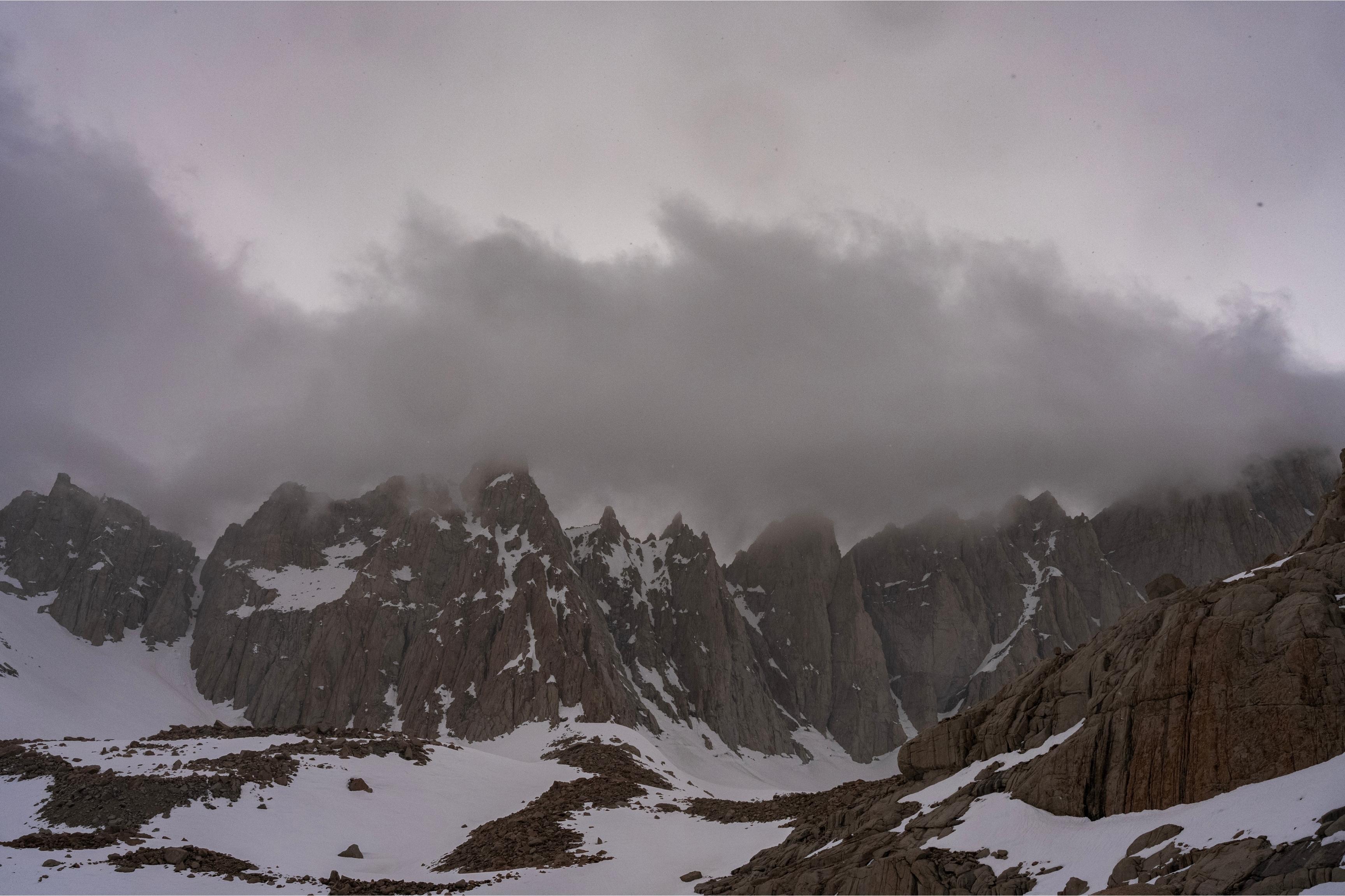
Reaching the summit of Mt. Whitney is one thing. Reaching the safety of your car afterward is another. The 21.4-mile round-trip hike has an elevation gain of over 6,000 feet. Near the summit, the air is thin, and the terrain can be snow-covered in places and icy.
It’s a dangerous climb that claims lives every year. In 2025, there were five fatalities on the mountain, the deadliest year of the last decade. In 2026, Whitney has already claimed one life near the summit on Jan. 19.
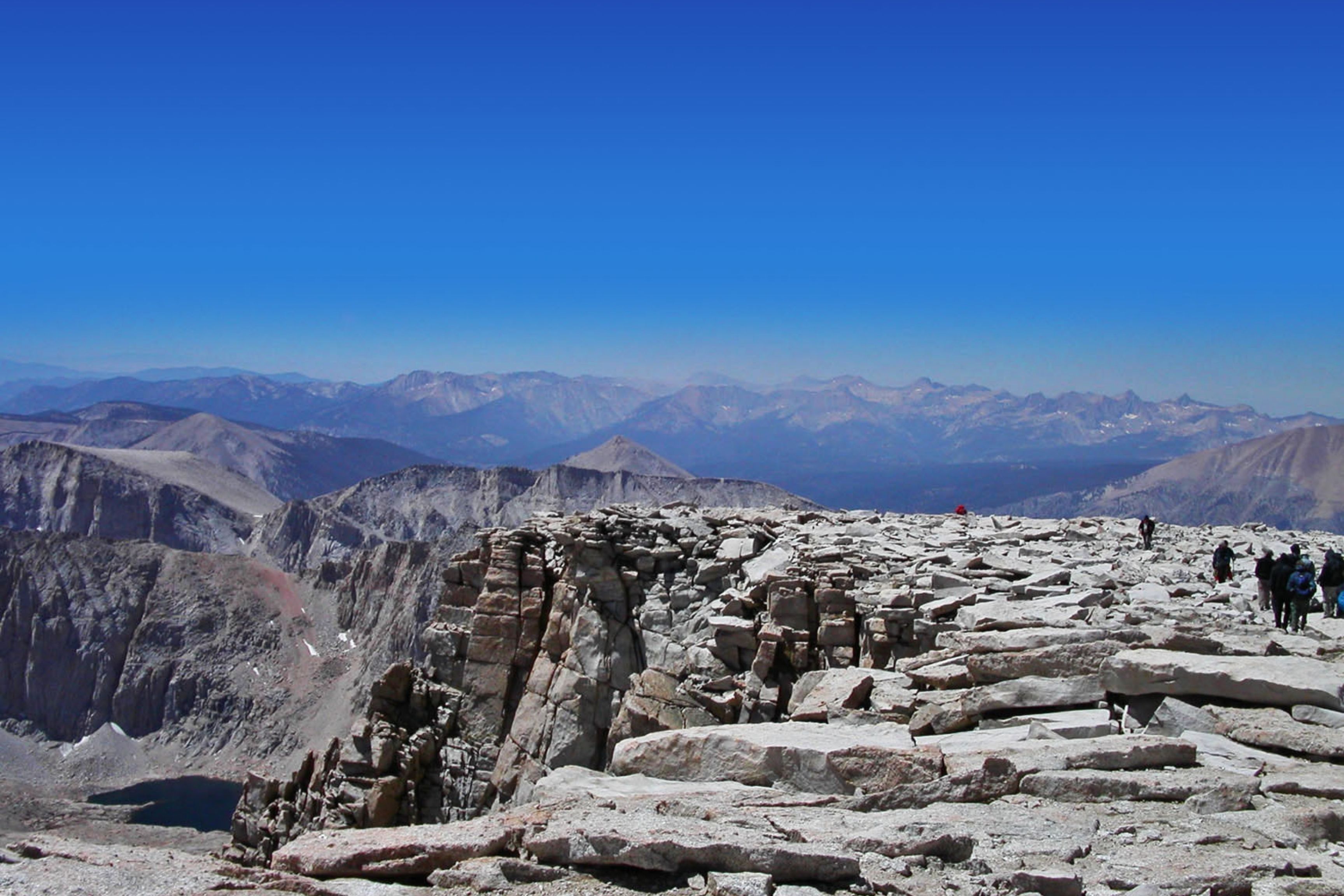
Despite the dangers, between 25,000 and 30,000 people successfully hike Mount Whitney every year. It is one of California’s most iconic and popular mountains, drawing hikers and climbers from around the world. The permit system is lottery-based and allots around 100 day permits and 60 overnight permits daily.
If you are hoping to climb Mount Whitney, the permit lottery for 2026 recently opened, but there are several factors worth considering before you apply. GearJunkie spoke with experts from the Inyo County Search and Rescue (SAR) and local guides about the safest times to hike the mountain and tips for ensuring success.
Mount Whitney Permit Lottery
When to Climb
Perhaps the most important factor in ensuring your safety on Mt. Whitney is the time you choose to go. With elevations over 14,000 feet, snow, ice, and winter storms can pose serious safety threats depending on the season.
Hikers can enter the permit lottery from now until March 1, and can request dates from May 1 to November 1. Registration is simple and requires just a few steps on the Recreation.gov website.
The period from May to June “tends to have the highest accident and fatality rates in the permit season,” according to Inyo County SAR. Snow and ice still cover Whitney during this time frame, and climbing the mountain requires alpine experience and specialized equipment.
July to August is usually the best bet for good conditions. While afternoon thunderstorms can happen, extreme weather is less likely during the summer. Inyo County SAR says that most rescues during this time are due to high-altitude sickness rather than falls. If you lack mountaineering experience, this 2-month window is the safest time to select for your lottery entry.
With shorter, colder days, hiking Whitney from September to October can pose additional hazards. Winter storms are possible, and most rescues stem from hikers being unprepared for the weather.
Group Size & Composition
The size and composition of a group are also important to consider when planning a trip up Mt. Whitney. GearJunkie spoke with Natalie Brechtel, a mountain guide with years of experience on Mt. Whitney and a background in wilderness medicine. She recommended going in small groups with people who have similar priorities — don’t go alone and don’t go with large groups.
Bretchel said that the ideal group size is about “having a small enough and dedicated enough group to stay together — folks who are clear about their objectives and priorities.”
“You need to be picky about your hiking partners,” Inyo SAR confirmed. “Only go with people whom you can trust. Random meet-ups are more likely to call for a rescue than groups who have hiked together many times.”
Even if your group is hiking at different paces, do not split up. Inyo SAR estimates that soloists and people who have split up from their group make up about 50% of all rescue deployments in a given year.
Staying Safe While Climbing Mt. Whitney
The Biggest Risks
Inyo County SAR deployed teams to 24 incidents on Mt. Whitney in 2025, according to statistics provided to GearJunkie. Ten rescues were for solo hikers or hikers who had split up from their group. Eight were for medical issues stemming from altitude sickness.
While Inyo SAR also receives many calls for exhaustion-related problems, this does not technically qualify as an “emergency.”
“We simply do not have the necessary capacity to respond to all exhaustion calls,” a representative said. “Further, all we could do is accompany them on their walk down on their own feet anyway.”
Altitude Sickness & Acclimatization
One of the most common reasons people call for help on Mount Whitney is altitude sickness. When ascending to too high an altitude too quickly, the body can struggle to adjust to the lower oxygen levels in the air, according to the Cleveland Clinic.
Symptoms include headaches, nausea and vomiting, fatigue, dizziness, and trouble sleeping. More serious consequences can include high-altitude cerebral edema and high-altitude pulmonary edema. The only cure is to descend to a lower altitude.
Last August, a hiker called Inyo County SAR for help because he “was unable to continue descending after pushing for the summit in a single day with little rest or acclimatization,” the agency said.
Brechtel notes that giving yourself time to acclimate is critical. “What I think gets overlooked is how huge of a jump going from sea level to 8,000 feet is on the body. It puts huge demands on our system. So, something as simple as spending two nights at 8,000 feet with a day hike higher is incredibly helpful at giving the body time to adjust,” Brechtel said.
While everyone responds to high elevations differently, 1 to 4 days of acclimatization is a good benchmark.
Another key part of acclimatizing is treating your body well. People need adequate sleep, hydration, and high-carb meals. Alcohol can exacerbate altitude problems, and is generally recommended against while climbing a peak like Whitney.
For more info on acclimatizing, check out this in-depth guide from Princeton University.
Training & Fitness
Whitney’s high elevation, coupled with the 21-mile hike in and 6,000 feet of elevation gain, makes it a serious alpine objective. Brechtel noted that everyday fitness is no indication of how well you’ll do on Whitney. She’s had clients who have run marathons and who have still struggled on the trail.
A common error she sees is hikers focusing too much on endurance. While, of course, this is a factor, on Whitney, people’s legs often give out before their cardio does.
“I think what often gets missed is that it takes a lot of leg and core strength to hike the steeper eastern Sierra trails,” Brechtel said.
If you live in California, Inyo SAR suggested hiking mountains like Mount Wilson, Gorgonio, Cucamonga, and San Bernardino in the summer or fall for training.
If you don’t live in a mountainous area, don’t worry. Elevation change or a hill (or even a stairmaster) plus a pack will work if there are no alternatives. After years of hiking Whitney with 45- to 50-pound packs, Brechtel says nothing prepares you as well as hiking steep trails with a pack on, plus some leg strength training.
Adequate Equipment
Beyond the obvious gear (see our list of 10 Essentials for Hiking), climbing Mt. Whitney might require other specialized gear, depending on what time of year you go.
“So many accidents come from the lack of experience with any of this equipment and judgment about when to use it,” Brechtel said. For example, she points out how many people confuse microspikes with crampons when packing for Whitney.

“There are lots of online retailers who advertise spikes as ‘crampons,’ even when they aren’t actually crampons. Spikes are insufficient on mountains; they’re made for flat trails,” Inyo SAR said.
An ice axe and self-arrest training are also necessary, as snow and ice are present on Whitney even in the summer and fall. Inyo’s SAR staff also recommends always bringing a waterproof jacket, even if the forecast looks clear.
Falls
Mount Whitney’s 99 switchbacks are one of the most famous (and dangerous) sections of the trail. In 2.2 miles, hikers gain roughly 1,800 feet in a series of grueling switchbacks. Falls often happen when people try to go up the snow to avoid the switchbacks.
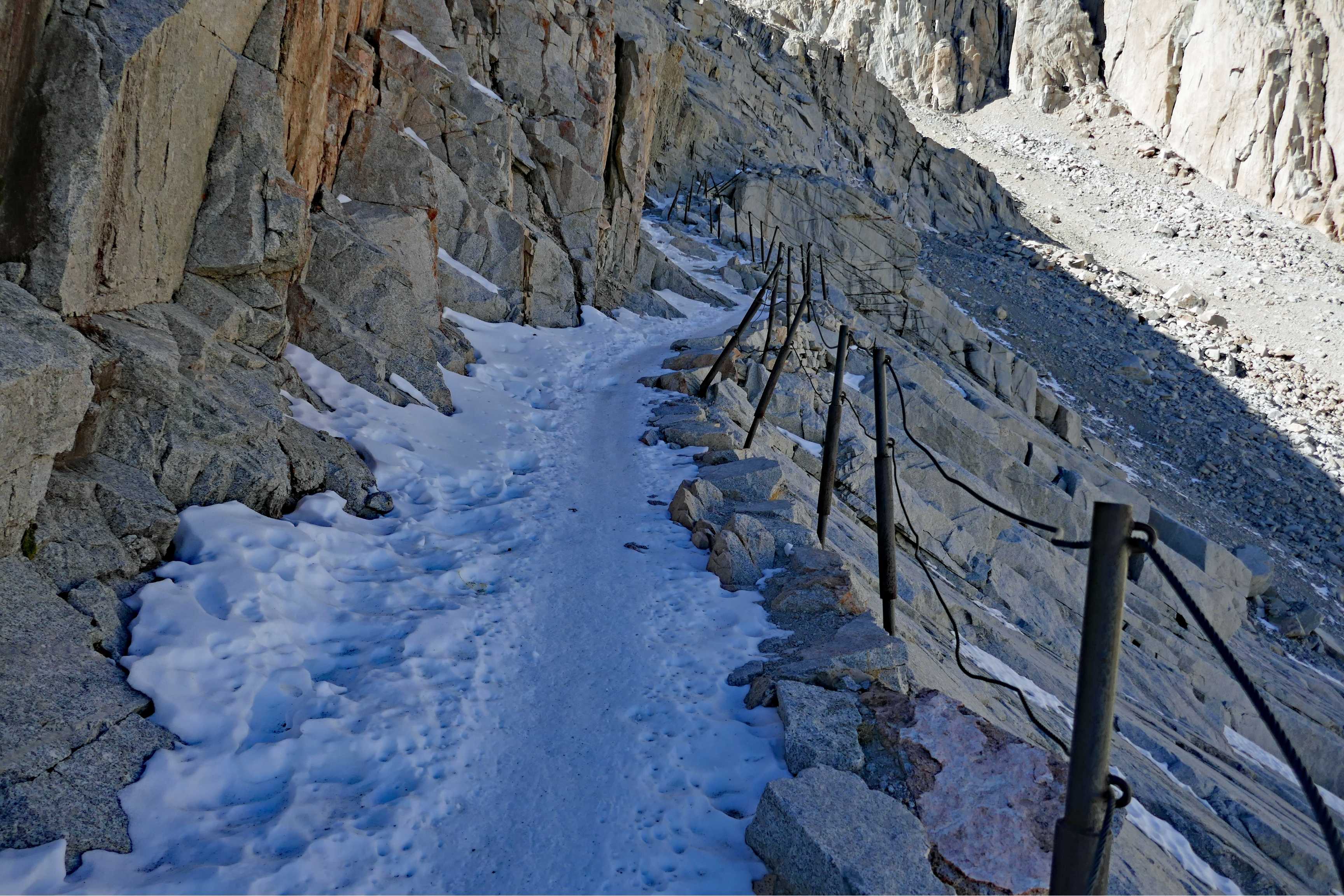
In fact, last November, a hiker called SAR for that very reason. They were going up off-trail, on the right side of the 99 switchbacks, when they fell on ice and sustained injuries. The section of the hike near the top sees similar incidents.
“Where folks encounter exposed rock scrambling, if they try to avoid this, they traverse a patch of snow that might last all season and also becomes very slippery,” Brechtel explained. Understanding how to move securely on firm snow with big fall consequences is critical to preventing potentially fatal falls.
Planning & Mentality
One of the most important factors in a successful Whitney hike is having enough time to complete it. On the day of the hike, start early and leave yourself plenty of time to complete the trail before nightfall.
It’s important to have a cutoff time. If you don’t hit the summit by your pre-planned cutoff, it’s time to turn back, no matter what. The speed you planned on going might turn out to be quite different than the speed you actually hike on the day.
“You need to make your own decisions about turnaround times and getting back according to your own speed,” according to Inyo County SAR; they also point out that it’s important to cross the snowfield at Trail Crest before the sun goes down.
“When you ascend the mountain, this snowfield might be soft. However, it solidifies as temperatures get cool in the late afternoon,” Inyo County SAR said. It becomes extremely dangerous and slippery to descend that snowfield in the dark, and no summit is worth your life.
“Turning around is not a failure, but a sign of wisdom,” Inyo SAR said. “Mountains like Mt. Whitney are not the place to find out what you’re capable of.”
For more information about climbing Mount Whitney and to apply for a permit, check the Recreation.gov website.

Read the full article here


